Improving The Accuracy Of Real-Time Traffic Data Gathered By The Floating Car Data Method
1. Introduction
Providing real-time traffic information is of interest of many parties. The information can help travelers for a better route choice [1] by avoiding traffic congestion. The use of traffic information can also increase the efficiency of the transport network.
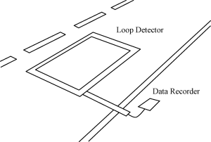
Traditionally, traffic data are collected using loop detectors implanted beneath road surface (see Fig. 1). However, the use of loop detectors is limited in term of coverage area and is prone to errors and malfunction. In California, about 30% of 25,000 loop detectors do not work properly in the daily basis [2].
Another method, so called Floating Car Data (FCD) method, has shown having great potential to acquire the traffic information at lower cost. The method uses probe vehicles enriched with an equipment to measure the vehicle velocity and position, and to transmit those data via a wireless network.
Nowadays, many cities collect traffic information using both methods: the traditional method using loop detectors and CCTV, and the FCD method. For example, the city of Seoul uses taxis as the probe vehicles with GPS positioning and wireless communication beside loop detectors and CCTVs [3].
For the reason, many previous publications were directed to discuss various issues related to FCD. Ref. [4] was one of the earliest publications prior the smartphones era. Ref. [5] discussed the use of transit vehicles, proposed the Kalman filter to estimate the vehicle position and velocity, compared the estimated velocity to those measured by a speed-trap,
and developed a graphical application to display the data in real-time. Ref. [6] studied the use of FCD using a microsimulation model, and evaluated the technique performance in terms of accuracy, reliability, timeliness, and coverage. Finally, they concluded that the number of probe vehicles was critical for coverage and accuracy, and recommended a penetration rate of 3% for freeways and 5% for surface roads to provide a reasonably accurate data. The penetration rate was defined as the number of probe vehicles during an averaging time interval on a traffic link having a flow rate $latex Q$.
In addition, Ref. [7] presented a large scale implementation of a traffic management
system, which was called OCTOTelematics FCD system. At that time, the system received
traffic data from 600 000 private vehicles. The paper also proposed the artificial neural
network and pattern matching algorithms to predict the short-term travel speed. They
evaluated their algorithms using the traffic on the Rome Ring Road in Rome, Italy, having a
length of 68.2 km with 2.4% penetration rate, 33 entries/exists, and 15 000 floating cars in
workdays. Ref. [8] proposed a method to use transit buses enriched with GPS sensor as probe
vehicles. The buses were used to measure the travel time data, and a procedure was proposed
to estimate the associated road travel time. Ref. [9] evaluated the reliability of using
a taxi dispatch system for real-time traffic information. They found that the taxi,
among commercial vehicle operations, was the most appropriate for the purpose;
however, the taxi suffered a number of issues. Their findings were: the taxi provided
good traffic data on high demand links, the dispatch system could not be a single
source of real-time data, the data from the vacant taxis needed careful consideration,
GPS location errors had little impact on traffic monitoring, and finally, the system
provided good data for a long road segment. Ref. [10] developed an integrated
smartphone-based platform to acquire, transfer, process, and display traffic and vehicle related
data.
In 2010, Ref. [2] demonstrated the use of FCD method in conjunction with smart-phone to
provide real-time traffic information, and performed the first field experiment that capable to
maintain 2–5% penetration rate involving 100 vehicles to cover a 10–16 km long freeway.
Proliferation of smart-phones brings the cost to develop the FCD infrastructure to very low
level [11].
However, the use of the low cost smart-phone suffers a number of issues. The first
issue is that the geo-location data collected by the device usually has low accuracy
(see Fig. 2). To avoid this issue, the collected data usually required some sort of
map-matching scheme to project the data to a correct road. However, this process
requires a significant computation resource and is often executed in the server side.

trajectory is depicted by a continuous red line.
The second issue is related with the privacy of those parties who contribute to provide the
traffic data. When a probe vehicle continuously submits its location, there is potential that the
vehicle position can be traced. To minimize this issue, Ref. [2] proposed the use
of the virtual trip line (VTL), which is a virtual line connecting two pre-defined
geo-coordinates (see Fig. 3). The use VTL has many benefits; a few are: it mimics the
traditional system on the basis of the loop detector, it can be located where the traffic
velocity data are important and can be measured accurately, and privacy can better be
protected.

trip line.